What are temporary ponds?
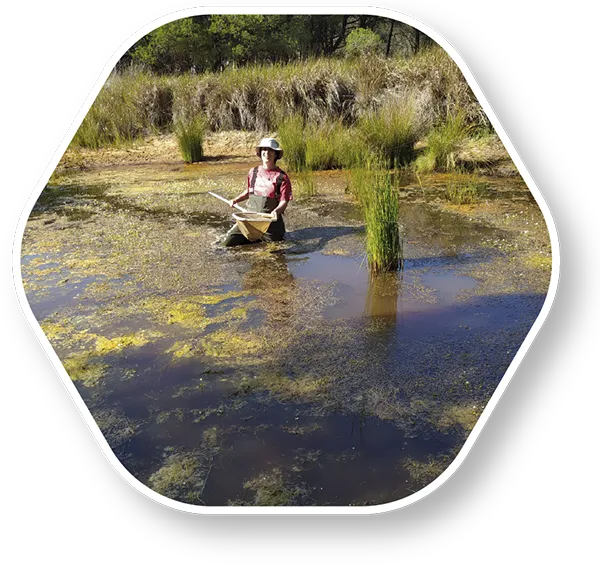
Temporary ponds are water bodies that usually flood every year and typically dry out in summer. This recurring drying is a natural part of their hydrological cycle. They host distinctive and unique fauna and flora that have developed adaptations to withstand this dry phase. However, these ecosystems are highly threatened by human activities, such as climate change, intensive agriculture, and invasive non-native species. With every flood, life returns!

Welcome to PondMapp!

This collaborative platform is designed for curious and adventurous people like you. Here, we invite you to capture and share photos of temporary ponds, along with some key information, to help build a living map of these fascinating aquatic ecosystems.

Thanks to your contribution, researchers will be able to assess the conservation status of temporary ponds, their unique biodiversity, and analyse their main threats, as these ecosystems are highly vulnerable to external pressures such as climate change, invasive non-native species, and land-use practices. Your perspective supports science… more than you might imagine!

Our goal

PondMapp was created with a purpose that is as clear as it is necessary: to make temporary ponds visible, and to conserve and protect those around us.

We cannot protect what we do not know, and many of these ponds are still undocumented. Your help is essential to build a network of temporary ponds through this citizen science project.

Temporary ponds are essential ecosystems for biodiversity. They contribute to societal well-being by regulating water and climate, act as unique habitats for flora and fauna, offer opportunities to enjoy the landscape, and serve as indicators of the environmental impact of our activities.

With your help, we aim to:

  • Map their distribution and conservation status.

  • Collect first-hand information from the field, thanks to people who visit and enjoy them, or simply come across them during their walks.

  • Analyse how factors such as climate, water management, basin alterations, land use, pollution, and invasive non-native species affect them.

By combining citizen science with scientific rigour, we turn every photo and every data point into key knowledge for protecting the ecosystems around us.

Why participate?

Your contribution makes a difference!

  • Temporary ponds are fragile ecosystems that often go unnoticed, yet they host remarkable biological diversity.

  • Their small size means that, many times, only with your help we are able to know where they are. Putting them on the map is essential for their protection.

  • With every photo you upload, you share valuable data that can be used to detect changes in the landscape, hydrology, or water quality.

  • This project combines citizen science with scientific rigour: contributions from volunteers generate unique knowledge that can support real conservation decisions.

  • Taking part is easy, accessible, and inclusive: all it takes is observing, taking a good photo, and sharing the information.

We invite you to look around you. That pond you pass by might be holding an important message for science… and you can help uncover it!

How we do it

Methodology

  1. Data submission: Once registered, you can use our form to upload your photo, its location, and related information in an extremely simple way—it takes less than 2 minutes.

  2. Validation: Our team checks that the basic information is complete and that the photo is suitable for analysis (confirming its visibility, geolocation, and temporary nature—we ensure it is not a permanent pond).

  3. Map integration: Ponds that meet these criteria are added to a public, interactive map, accessible to everyone.

  4. Analysis and dissemination: Based on the collected data, reports are produced, trends are identified (e.g. presence of invasive non-native species, vegetation changes, basin alterations), and results are shared.

Every contribution turns a simple image into an environmental treasure.

FAQs

To upload a pond, you need to register in the system by providing an email address and a username (see our data protection policy). At a minimum, we require the pond’s location together with its image (coordinates or an approximate municipality), as well as the name of the pond (if known—or feel free to give it a new one!).

Finally, you may optionally complete a short form with a few questions about the surrounding environment where the photos were taken. Don’t worry if you are unable to answer all of them.

We need to geolocate your photo in order to place it correctly on the map. In the form, you can easily enter the coordinates, or simply take the photo with your phone’s location services enabled.

To upload a pond, you need to register in the system by providing an email address and a username. At a minimum, we require the pond’s location together with its image (coordinates or an approximate municipality), as well as the name of the pond (if known—or feel free to give it a new one!).

Finally, you may optionally complete a short form with a few questions about the surrounding environment where the photos were taken. Don’t worry if you are unable to answer all of them.

Our team reviews your submission and, if everything is correct, it is added to the map along with the associated information. You will be able to view it in “My account”, and the collection of photos will be used for scientific and conservation purposes.

Yes. You will become part of a community committed to conservation, as your contribution is essential to the project’s outcomes. You will also be informed when more detailed results are produced, giving you the opportunity to share your views and feedback.

This information will make it possible to create maps of temporary ponds in your local area, highlighting a natural heritage that often goes unnoticed. In turn, this can help promote local conservation actions, such as installing informative signage, encouraging shared activities like guided walks or outings, and supporting environmental education initiatives. Through this, you can help protect temporary ponds from potential threats, including inappropriate uses such as dumping and pollution.

By contributing to the project’s results, you help generate knowledge that would not otherwise exist.

We encourage you to enjoy these ponds, observe them, photograph them, and walk alongside the beauty of this natural heritage—while avoiding their degradation and helping to protect them through your knowledge.

Join the change!

Every pond, every photograph, every data point matters. By taking part in this project, you are helping to protect ecosystems that are unknown to many people, yet vital for biodiversity, the water cycle, and the planet.

Sign up now and join the change! Get your camera or mobile phone ready, find a nearby pond, capture the moment… and upload it to PondMapp! Together, we can make the invisible visible.